



Storm Bertha puts Florida to Louisiana on alert
The National Hurricane Center reported Monday on the formation of Tropical Storm Bertha in the Gulf of Mexico, with maximum sustained winds of 40 miles per hour and alerts now in effect from Florida to Louisiana.

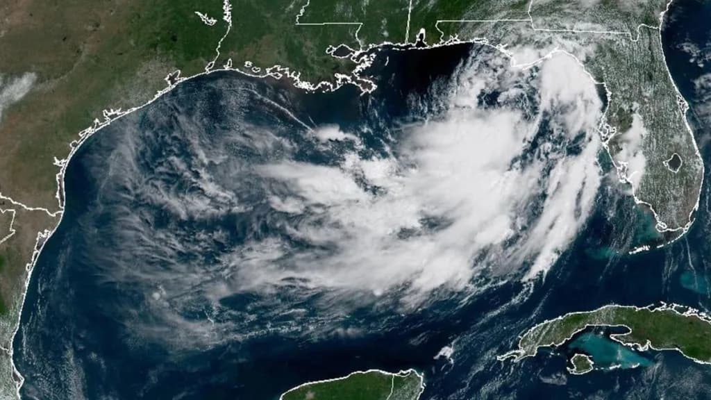
The National Hurricane Center (NHC) reported Monday on the formation of Tropical Storm Bertha. The phenomenon is located in the waters of the Gulf of Mexico and has already put several states on alert. Bertha is currently about 110 miles south of Panama City, Florida. It is also located about 190 miles southeast of Mobile, Alabama, according to the most recent report. The storm presents maximum sustained winds of 40 miles per hour. Its movement is slow, with a west-northwest movement of just 3 miles per hour.
Active alerts along the Gulf Coast
The National Hurricane Center indicated that a storm surge watch is in effect. This covers the border between Alabama and Florida to the mouth of the Mississippi River. A tropical storm watch is also active for a wider region. This spans from the Ochlockonee River in Florida, westward to the border between Jefferson and Plaquemines parishes in Louisiana. These watches aim to prepare coastal communities for the imminent arrival of the weather phenomenon in the coming hours.
What these alerts mean for the population
A tropical storm watch indicates that conditions typical of this type of phenomenon could occur. This could happen within the indicated area in the next 24 to 48 hours. Meanwhile, a storm surge watch warns of a greater risk to human life. There is the possibility of flooding caused by water advancing from the coast inland. This type of flooding could occur during the next 48 hours in localities under active alert.
Storm surge up to 4 feet in Louisiana and Mississippi
According to the hurricane center, potentially life-threatening storm surge could occur. These could reach up to 4 feet in height in some coastal areas of Louisiana and Mississippi. Meteorologists also warned about the possibility of additional phenomena during the week. Bertha could generate one or two isolated tornadoes over the Big Bend region in Florida. This combination of risks has led authorities to strengthen precautionary recommendations throughout the Gulf Coast area.
Risk of flash flooding through Friday
Specialists warned about possible flash flooding in an extensive coastal strip. This would span from western Florida to central Texas. The risk of these floods would remain in effect until next Friday, according to current projections from the meteorological agency. Local authorities are closely monitoring the evolution of precipitation associated with the system. This threat represents one of the main concerns for communities located along the Gulf Coast.
Precipitation up to 5 inches in Louisiana
Meteorologists detailed that precipitation could reach between 3 and 5 inches along the Louisiana coast. In some specific areas, even greater amounts are expected. The area south of Lake Pontchartrain stands out as one of the regions most likely to receive heavy rainfall. Local authorities have asked residents to stay informed about the system’s evolution. This rainfall accumulation could generate additional complications in urban areas with limited drainage systems.
Possible additional alerts in coming hours
The hurricane center indicated that additional watches could be issued for parts of the northern Gulf Coast. This possibility depends directly on how Bertha evolves in the coming hours. Therefore, the agency urged the population to stay alert to the storm’s progress. This recommendation applies even to relatively distant locations, such as some areas of Louisiana and Texas. Constant vigilance is key to anticipating possible changes in the trajectory or intensity of the weather phenomenon.
Fausto strengthens in the Mexican Pacific
Meanwhile, in the eastern Pacific Ocean another relevant weather phenomenon is recorded. Tropical Storm Fausto intensified Monday and is approaching hurricane strength in the open ocean. Fausto is located off the western coast of Mexico, although it currently poses no direct threat to land. The system is maintaining its trajectory away from populated areas for now. This second phenomenon adds to the active cyclone season currently affecting the American continent.
Technical data on Fausto’s evolution
Fausto registered Monday maximum sustained winds of 70 miles per hour. The system was located about 745 miles southwest of the southern tip of the Baja California peninsula. According to the hurricane center, the storm was moving northwest at a speed of 10 miles per hour. This trajectory keeps it away from Mexican coasts for now. Meteorologists will continue monitoring both phenomena in the coming days, while authorities in different states prepare for the possible arrival of adverse weather conditions.
Canal oficial
Únete a nuestro canal de WhatsApp
Recibe las noticias más importantes al instante, sin spam. Solo lo que importa, cuando importa.
Etiquetas

Comentarios
Inicia sesión para comentar
Es gratis y toma un minuto. Con tu cuenta también podés:
- Comentar y participar en la conversación
- Guardar notas para leer después
- Ver tu historial de lectura
- Recibir el boletín con tus temas favoritos