



Alert in Texas for Extreme Rainfall and Flooding
Texas faces a major climate threat this week as slow-moving storms could deliver the equivalent of an entire summer’s rainfall, with flash flood risks extending across much of the state. Hill Country, west of San Antonio, is particularly vulnerable, with 15 to 30 centimeters of rain already recorded since Monday night.

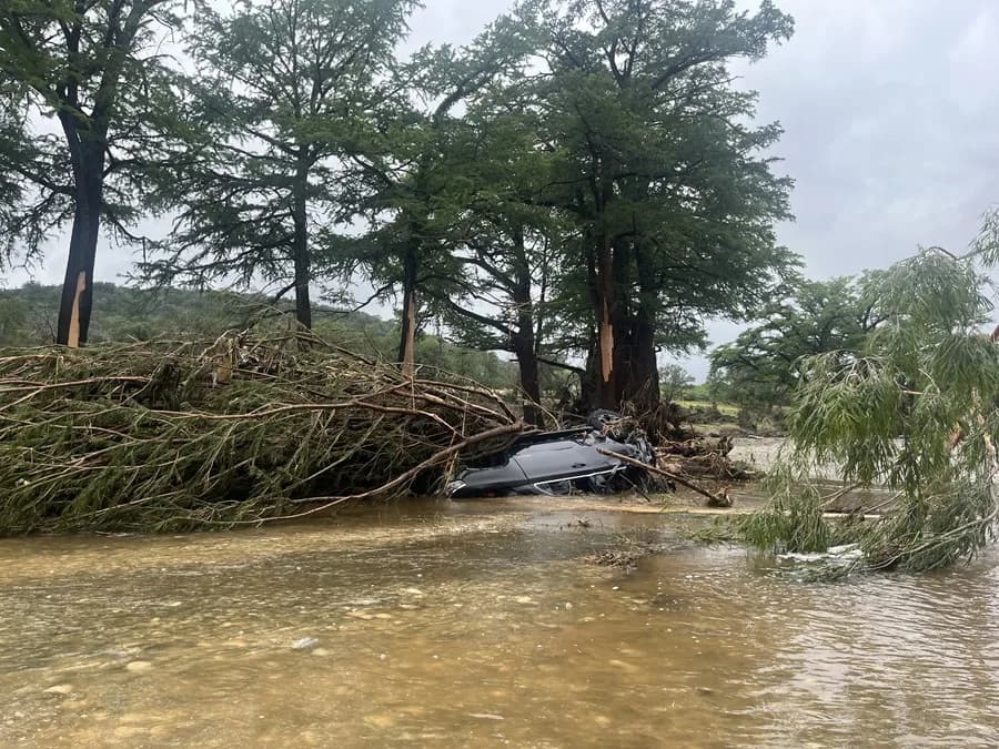
Texas faces a major climate threat this week. Slow-moving storms could leave the equivalent of an entire summer’s worth of rain. The risk of flash flooding extends across much of the state.
Multiple alerts were in effect Tuesday morning for Hill Country. This zone is located west of San Antonio and is particularly vulnerable. Between 15 and 30 centimeters of rain fell there since Monday night fell.
Medina, Uvalde, and Bandera counties recorded the most intense precipitation. Emergency teams conducted multiple water rescues during Tuesday’s early morning hours. Several vehicles became trapped in high water zones and were swept away.
Roads Closed and Emergency Rescues
The Medina County Emergency Management Coordinator, Mark Chadwick, confirmed the severity of the situation. He detailed that approximately 18 county roads remain impassable due to water. A bridge was even completely submerged due to the flooding.
Near the city of Sabinal, in Uvalde County, another water rescue was also reported. The local Volunteer Fire Department confirmed the emergency operation. The situation is repeating at various points throughout the affected region.
The highest risk zone extends from San Antonio westward across the state. It encompasses Hill Country, the Edwards Plateau, and the Rio Grande Valley. This area could receive in just a few days the typical rainfall of an entire summer.
The Ghost of Last Year’s Flooding
This new threat comes just one year after a devastating tragedy in the region. The July 4 floods left more than 130 people dead. Among the victims were 25 girls and two counselors from Camp Mystic.
Hill Country is particularly prone to this type of natural disaster. Its steep slopes and shallow soils favor sudden flooding. The exposed rocky bed repels water instead of absorbing it.
Flood alerts are currently in effect for nearly 6 million people. Cities including Austin, Del Rio, San Angelo, and San Antonio are under surveillance. Local authorities are constantly monitoring the evolution of precipitation.
Official Response to the Emergency
Texas Governor Greg Abbott activated the state emergency response starting Sunday. The measure seeks to make available all necessary state resources. This includes water rescue teams and support helicopters.
«Texans are urged not to drive or walk on flooded roadways,» warned an official statement. The governor’s office emphasized that waters can be deceptively deep and fast-moving. The call aims to prevent personal tragedies during the critical days ahead.
Local authorities are working in coordination with state and federal teams. The objective is to respond quickly to any flooding that occurs in the region. The absolute priority is protecting human lives during this climate emergency.
An Increasingly Frequent Phenomenon
Extreme rainfall events like this are becoming increasingly common. Pollution that warms the planet constantly drives temperatures upward. Warmer air retains greater amounts of atmospheric moisture.
Weather systems then squeeze that moisture out like a saturated sponge. The result is intense downpours and frequently very localized rainfall in specific areas. This climate pattern is repeating with greater frequency in recent years.
The current threat is fueled by abundant moisture from the Gulf of Mexico. This collides with a stationary front and a pocket of atmospheric energy. The combination is ideal for generating slow-moving and persistent storms.
Rainfall That Could Reach Historic Levels
The National Weather Prediction Center issued a level 3 out of 4 risk alert. This alert remains in effect until Wednesday for much of the region. Some areas could even reach the maximum risk level, 4 out of 4.
These high-risk episodes represent a minimal proportion of days in the year. However, they generate more than 80% of all flood damage. They are also responsible for 36% of deaths related to this type of disaster.
Rainfall accumulation could range between 10 and 20 centimeters in the zone. Locally, some areas could receive up to 38 centimeters of precipitation. That figure would exceed the typical summer rainfall for the entire season in Del Rio.
Overflowing Rivers and Prolonged Risk
Significant flooding is expected on roadways and urban areas of the affected region. The flow of rivers and streams will increase considerably over the next few days. Some bodies of water could overflow completely given the intensity of the rainfall.
The risk of flash flooding will continue Thursday, mainly in southwest Texas. Areas such as Del Rio, Midland, and San Angelo will remain under close watch. Storms could intensify unpredictably at various points each day.
The threat is expected to diminish finally toward Friday or Saturday. However, the possibility of isolated showers in western parts of the state will persist. Authorities are asking residents to remain cautious until the situation stabilizes.
Canal oficial
Únete a nuestro canal de WhatsApp
Recibe las noticias más importantes al instante, sin spam. Solo lo que importa, cuando importa.
Etiquetas

Comentarios
Inicia sesión para comentar
Es gratis y toma un minuto. Con tu cuenta también podés:
- Comentar y participar en la conversación
- Guardar notas para leer después
- Ver tu historial de lectura
- Recibir el boletín con tus temas favoritos