



Alert in Texas: Dozens Rescued from Flooding
A new round of storms battered south Texas on Wednesday as the already water-saturated region faced the risk of potentially deadly flooding, with accumulated rainfall prompting dozens of water rescues and meteorologists warning of additional catastrophic precipitation.

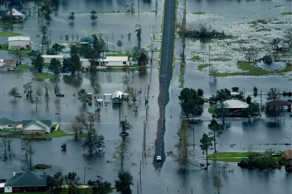
A new round of storms battered south Texas on Wednesday. The region was already completely saturated with water. The risk of potentially deadly flooding increases hour after hour.
Relentless rains have accumulated up to 16 inches, about 40 centimeters. This amount prompted dozens of water rescues in various communities. Meteorologists warn of additional precipitation that could prove catastrophic.
According to the National Meteorological Service, the threat is not over yet. By the weekend, more than half of the annual average could fall. This amount would be concentrated in just a few consecutive days.
An alert not seen since 2025
Wednesday marked the second consecutive day with maximum alert in effect. The Weather Prediction Center classified the risk as extreme again. This is the first time this has occurred on consecutive days since April 2025.
The affected area includes the region known as Texas Hill Country. This territory suffered devastating floods last July. That tragedy left more than 130 dead, including 25 girls from a camp.
Alerts were issued again Wednesday for Uvalde County. It is one of the areas hardest hit by the previous disaster. Other nearby counties also remain under strict meteorological surveillance.
Mass rescues and disaster declaration
At least 45 people were rescued from flooding in Uvalde. The count corresponds only through late Tuesday night. Several additional rescues were conducted in neighboring Medina County.
Faced with the severity of the situation, Governor Greg Abbott took drastic action. He declared a state of disaster in 59 counties across the state. The decision aims to facilitate the deployment of state emergency resources.
The storms also generated a tornado near Interstate 10. The phenomenon occurred northwest of San Antonio on Wednesday morning. Social media videos showed lightning flashes and debris spinning through the air.
A climate pattern described as «the worst-case scenario»
The current threat combines slow-moving rains over already saturated areas. These areas accumulated between 15 and 40 centimeters since Monday night. The storms will now discharge between 5 and 10 centimeters of additional rain per hour.
The highest-risk regions are nearly identical to those affected on Tuesday. They include parts of Hill Country, the Edwards Plateau, and the Rio Grande Valley. This area maintains the maximum alert level for flooding.
The Weather Prediction Center described this repetitive pattern as the worst-case scenario possible. It explained that saturated soil requires far less rain to generate severe flooding. Any additional precipitation will quickly become surface runoff.
Catastrophic impacts on the US 90 corridor
The weather agency warned of possible catastrophic impacts on specific stretches. The US 90 highway corridor west of San Antonio is particularly vulnerable. Surrounding areas also face considerably high risk levels.
Risk extends at level 3 of 4 toward peripheral areas. Even Houston, farther from the epicenter, maintains a level 2 risk. Flooding is expected on roadways, urban areas, and possibly some homes.
Creeks, streams, and rivers throughout the region will rise considerably in the coming days. Some bodies of water will exceed their normal flood levels. The situation demands maximum caution from residents throughout the area.
The forecast for the coming days
By Thursday, the highest-risk zone will diminish slightly in extent. However, it will still encompass some of the currently hardest-hit areas. Del Rio, Midland, and San Angelo could suffer additional flooding that day.
Friday would finally mark the beginning of considerable storm diminishment. However, a lesser threat will persist mainly in the state’s western regions. Authorities ask for continued vigilance until the situation returns to normal completely.
This type of extreme weather event is becoming increasingly frequent in the region. Pollution that warms the planet raises temperatures steadily. Warmer air retains more moisture, generating more intense and localized downpours.
A geography that magnifies the danger
Hill Country is especially vulnerable due to its particular geological characteristics. Its steep slopes and shallow soils repel intense rains. Exposed bedrock prevents water from filtering properly.
The current threat is fueled by abundant moisture from the Gulf of Mexico. This collides with a stationary front and accumulated atmospheric energy aloft. The combination is ideal for generating slow-moving and persistent storms.
As authorities coordinate rescues and strengthen emergency response, the community remains on edge. The memory of last year’s tragedy increases widespread concern. Texas hopes this new round of storms does not repeat that devastating outcome.
Canal oficial
Únete a nuestro canal de WhatsApp
Recibe las noticias más importantes al instante, sin spam. Solo lo que importa, cuando importa.
Etiquetas

Comentarios
Inicia sesión para comentar
Es gratis y toma un minuto. Con tu cuenta también podés:
- Comentar y participar en la conversación
- Guardar notas para leer después
- Ver tu historial de lectura
- Recibir el boletín con tus temas favoritos